


A talaj több, mint gondolnád – hogyan segíthet a talajtérképezés a tájépítészetben? A talaj nem csupán az, amin járunk – hanem az alap, amely meghatározza egy táj fenntarthatóságát, vízháztartását és biodiverzitását. Félegyházi Fruzsina előadása bemutatja, hogyan lehet a talajtérképezés eszközeit felhasználni városi és természeti környezetben egyaránt. Miért fontos ismerni a talaj szerkezetét és összetételét? Hogyan befolyásolja a városi burkolt felületek a hősziget-hatást? És miért elengedhetetlen a megfelelő talajválasztás az öntözés és a vízmegtartás optimalizálásához? Ha érdekel, hogyan lehet a talajadatokból hasznos tervezési információkat nyerni, ezt az előadást ne hagyd ki!
Az előadás magyar nyelvű.
Az előadás megtekintését a Magyar Építész Kamara 0,5 ponttal honorálja abban az esetben, ha helyesen válaszolsz az alább feltett kérdésre. A választ a titkar.tajepiteszek@gmail.com címre kérjük elküldeni. A kamarai pontszerzésre vonatkozó igényt a jelentkezési felületen tudod feltüntetni. Az igazolásokat a regisztráció során megadott e-mail címre fogjuk kiküldeni.
Kérdés: Miért elengedhetetlen a talajtérképezés a fenntartható tájépítészeti tervezésben?
Az előadást megtekinteni CSAK @gmail.com email címmel lehetséges. Regisztráció és jelentkezés után a megadott @gmail.com végződésű email címre kapott linken érhető el a felvétel. Ehhez azonban a megadott gmail-es címhez tartozó Google-fiókkal kell bejelentkezni a Youtube-ra is!
Ha a fentiek mellett is problémája adódik a megtekintéssel, a horvath.mate@tajepiteszek.hu címen kérhet segítséget.
Please registrate in order to have your ticket for the presentation!
Európai faiskolák, és a szektor helyzete
3 000 Ft
Nagy fa átültetése
3 000 Ft
A korona alakja
3 000 Ft
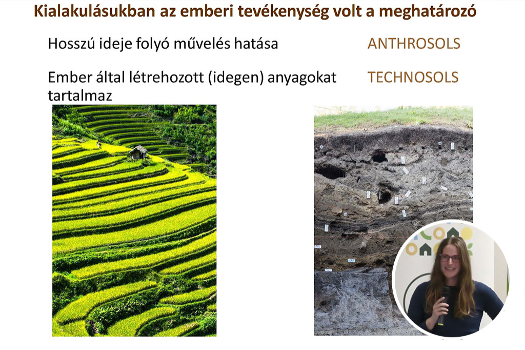
A talajegészség, talajleromlás és a talajfunkciók összefüggései Magyarországon
3 000 Ft
Növény-mikróba szimbiózisok: pótolható-e, ami elveszett?
3 000 Ft
Visionary
3 000 Ft
Topotek 1 modus operandi - current strategies
3 000 Ft
Public Plantings In Times Of Climate Crisis
3 000 Ft
Landscape Design with an Approach to Humanity and the Environment, Landscape in Context
3 000 Ft
Managing Space: Strategies for Sustainable Design
3 000 Ft
Planting for the Future
3 000 Ft
Working with the Power of Nature
3 000 Ft
How Budapest Turns Their Citizens' Mindset about Green Infrastructure Maintenance and Development
3 000 Ft
Beyond Diversity
3 000 Ft
Rebirth of a 200-year-old Park – Budapest's Városliget
3 000 Ft
Hungarian Landscape Architecture from IFLA 1984 to IFLA EU 2024
3 000 Ft
Élő város
3 000 Ft
Ásványhiány pótlás, a katalizátor élhető, zöld helyek létrehozásához
3 000 Ft
Tájépítész műszaki ellenőrzés: Gyakori tervezési és kivitelezési hibák
3 000 Ft
Aranybulla emlékmű környezete
3 000 Ft
Gyula zöldfelületeinek és fenntartásának fejlődése
3 000 Ft
A Népliget megújításának örökségvédelmi aspektusai
3 000 Ft
Mennyibe kerül? - kert- és parképítés fajlagos költségei
3 000 Ft
Történeti kertek faállományának felmérési módszertana
3 000 Ft
Patakrevitalizáció gyorstalpaló, megvalósult jógyakorlatok
3 000 Ft
A zalakarosi fenntartható városi csapadékvíz kezelő rendszer (SUDS)
3 000 Ft
Művészi terepplasztikák a kortárs tájépítészetben
3 000 Ft
Nemzetközi network, együttműködések lehetőségei
3 000 Ft
Ma már mindenki fotográfus, akinek telefon van a kezében
3 000 Ft
Civil együttműködés és tájépítészet a vizes élőhelyek fenntarthatósága érdekében
3 000 Ft
A jövő zöldfelülete? – A zöldhomlokzat tervezés műhelytitkai
3 000 Ft
Városi esőkertek közterületi tervezése
3 000 Ft
Tavak egy magánkertben
3 000 Ft
A városligeti tó tervezett rekonstrukciója
3 000 Ft
Összefüggéseiben mutatott koncepciók a Snohetta-irodából
3 000 Ft
Genius Loci a finn tájban
3 000 Ft
Dizájn és természet
3 000 Ft
Természetes úszómedencék beültetése
3 000 Ft
Vegyes évelő kiültetések – természetes megközelítés, a diverzitás optimalizálása és a fenntartási igények minimalizálása céljából
3 000 Ft
Jövő fái a klímakrízis tükrében
3 000 Ft
Keretfeltételek és kihívások, technológiák a sikeres szivacsváros projektekhez
3 000 Ft
A szivacsváros elv alkalmazása a városi fák, mint kék-zöld infrastruktúra elem esetében
3 000 Ft
A szivacsváros-elv a fák szempontjából: háttere, alapelvei és működése
3 000 Ft
Egy kert megálmodása és megvalósítása
3 000 Ft
Növények mindenekelőtt
3 000 Ft
Művészi ökológia és transzformatív városi zöldfelület-fejlesztés
3 000 Ft
Növény design a Great Dixter kert stílusában
3 000 Ft